Yakima Master
Plan
In collaboration with Urbanadd &
Johnston Architects


Yakima Master
Plan
In collaboration with Urbanadd &
Johnston Architects
The Yakima
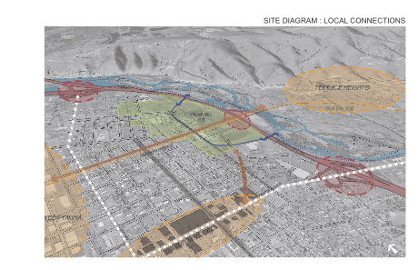
Boise Cascade site consists of 211 acres, just less than a mile
long and just less than a half mile wide. The East border is the
large radius freeway sweep of I-82. The West border is the serrated
edge of a mixed use/residential neighborhood. To the north, a mix
of residential and commercial form a varied border. To the south,
large scale commercial and a mix of near down town uses dominate.
The east west City street grid shifts
near the north south half way point of the site. Blocks are longer
in the north south direction and are roughly 400’ x 500’ center
of street to center of street. A future connector bisects the north
and south parts of the site and will reach to 1st. Avenue to the
west and Terrace Heights to the east.
The use grain of the site begins with
a north south band of coarse grain, large scale uses against the
freeway. Center to the site, the old mill ponds will be recreated
generating a medium grain walking
district of shops, restaurants, wineries,
offices and other uses. This zone runs north south as well and separates
the large scale retail from a variety of mixed uses, descending
in size and integrating with the mixed use/residential neighborhood
on the west.
The circulation hierarchy consists of
100’ boulevards, 80’ connectors and 60’ neighborhood streets. These
are further supplemented by pedestrian alleyways and vehicular alleyways.
Central to the Mill Pond District is a couplet consisting of a bike
lane, a parking lane and two one-way driving lanes. These flank
a channel of water with shade trees and other public amenities.
In the development of this hierarchy,
the following goals have been considered:
1.Efficient
delivery of vehicular traffic to the large scale retail zone.
2. The use of large scale retail parking
areas to supplement parking requirements for the Mill Pond zone.
3. Activation of the Mill Pond zone through
the calmed and careful introduction of vehicular traffic.
4. The linkage of large parking areas
to the Mill Pond zone through pedestrian alleys.
5. The extension of the residential/mixed
use neighborhood street grid into the site in a manner that manages
traffic while integrating the new district with the existing while
promoting pedestrian traffic.
6. The use of pedestrian alley ways to
enhance goal five.
7. The use of interior block alley ways
to provide short term parking for the Mill Pond zone.


Cottage